|
|
||
.jpg) |
|
|
|
|
||
|
I. BALKAN PASSES |
||
|
|
||
|
|
|
|
|
|
||
|
I. BALKAN PASSES |
||
|
Balkan (Балкан) or Old Mountains (Стара планина)
|
|
In my personal experience it is important to plan ahead and know all
routes & passes where it would be best to cross this or that mountain. Here are some names you should know: Balkan (Балкан) - Is the name of the entire region of South - East Europe. |
Old Mountain (Стара планина), (or Balkan) is a mountain ridge stretching from the western BG/Serbia border to the Black Sea to the east (please look the next map). This mountain crosses the country and divides it into two almost equal parts: Northern Bulgaria and Southern Bulgaria. | |
|
In Internet can be found a lot of information concerning Balkan: https://en.wikipedia.org/wiki/Balkan_Mountains https://www.britannica.com/place/Balkan-Mountains http://www.visitbulgaria.net/en/articles/balkan_mountain_range.html |
||
 |
||
|
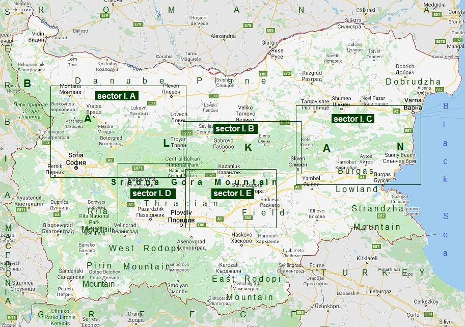
BALKAN, or as we call it “The Old Mountain”: The name of this mountain is deceiving. Geologically it is a young folded mountain, formally consists 3 parts (almost as I have parted it in 3 sectors above): - West part (from Serbian border to Zlatishki Pass): Sector I. A ; - Central part (from Zlatishki Pass to Vratnik Pass), Sector I. B is the highest part of the mountain (here is the highest pick “Botev” at an altitude of 2376 meters). Most of this area is a protected zone, so called "Central Balkan Park"; - East part (from Vratnik Pass to Black Sea), Sector I. C - It is a low and wider part of the mountain. I will list Balkan |
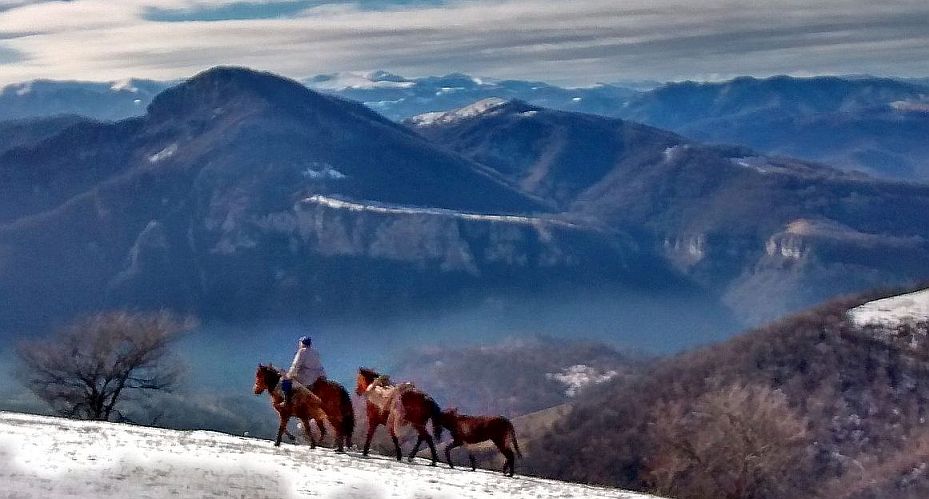
Passes in order, from west to east, giving a brief description of their features. I also will add photos I have taken on the tours I have done in the years.
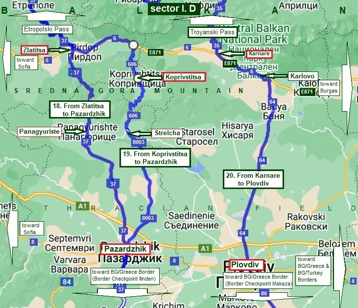
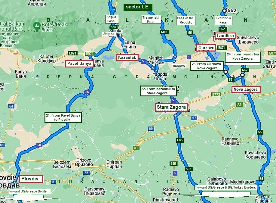
I will add two more sectors: sector I. D and sector I. E. This will illustrate how to cross Sredna Gora Mountain, which is parallel to Balkan, but not so high and long. This information will help bicyclists planning to cross the country in direction north - south or back. For easier handling, I split the Chapter I in 5 sections responding to the 5 map sectors - for detail information please follow the sector links below! |
|
|
|
||
|
Content |
|
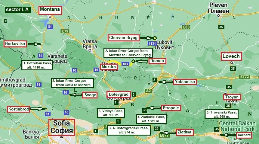
| Sector I. A | Sector I. C |
| 1. Petrohan Pass | 12. Kotlenski Pass |
| 2. Iskar River Gorge | 13. Varbishki pass |
| 3. Vitinia Pass (and Botevgradski Pass) | 14. Rishki pass |
| 4. Zlatishki Pass | 15. Aitoski pass |
| 5. Troyanski Pass (Beklemeto) | 16. Dyulinski Pass |
| 17. Pomoriiski Pass | |
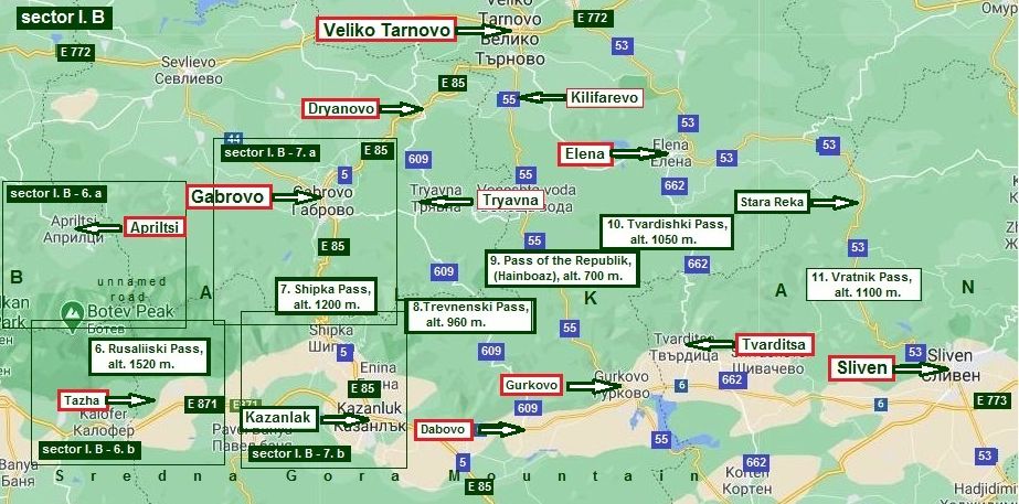
| Sector I. B | Sector I. D |
| 6. Rusaliiski pass |
18. From Zlatitsa to Panagyuriste to Pazardzhik |
| 7. Shipka Pass | 19. From Zlatitsa to Koprivstitsa to Pazardzhik |
| 8. Trevnenski Pass | 20. From Karnare to Karlovo to Plovdiv |
| 9. Pass of the Republic (Hainboaz) | Sector I. E |
| 10. Tvardishki Pass | 21. From Pavel Banya (Kazanlak) to Plovdiv (Chirpan) |
| 11. Vratnik Pass | 22. From Kazanlak to Stara Zagora |
| 23. From Gurkovo to Nova Zagora | |
| 24. From Tvarditsa to Nova Zagora | |
|
|
|
|
1. Petrohan Pass: 2. Iskar River Gorge: 3. Vitinia Pass (and 3.A Botevgradski Pass): 4. Zlatishki Pass: 5. Troyanski Pass (Beklemeto): |
From Montana to Berkovitsa to Kostinbrod to Sofia (Road 81); From Sofia to Svoge to Mezdra to Roman to Cherven Bryag (Road 16); From Yablanitsa (and Roman) to Botevgrad to Sofia (Roads 3 & 1); From Yablantsa (from Roman) to Etropole to Zlatitsa (Road 37); From Lovech to Troyan to Karnare (Road 35). |
|
|
|
|
6. Rusaliiski pass: 7. Shipka Pass: 8. Trevnenski Pass: 9. Pass of the Republic (Hainboaz): 10. Tvardishki Pass: 11. Vratnik Pass: |
From Apriltsi to Tazha (unnamed road); From Gabrovo to Kazanlak (E 85, road 5); From Tryavna to Dabovo (road 609); From (Veliko Tarnovo to) Kilifarevo to Gurkovo (road 55); From Elena to Tvarditsa (road 662); From Elena to Sliven (road 53). |
|
|
|
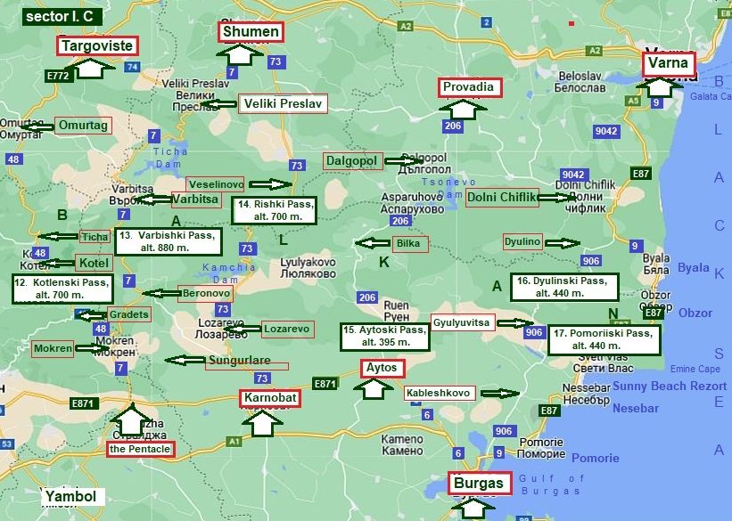
Sector I. C includes the east part of the Balkans. The mountain in its eastern part is getting wide, it is not so high and the road profile include several shorter ascents and descents. This part of the mountain is easy to |
access, and easy for bicycling, riding either from the north or the south. I will give more detailed descriptions of the passes here - it would be helpful for bicyclists intending to cross the country from north to south or back. |
|
12. Kotlenski Pass: 13. Varbishki pass: 14. Rishki pass: 15. Aitoski pass: 16. Dyulinski Pass: 17. Pomoriiski Pass: |
From Targoviste to Omurtag to Ticha to Kotel to Gradets (road 48) to the Pentacle (road 7); From Shumen (Targoviste) to Varbitsa to the Pentacle (to Sungutlare to Karnobat) (road 7); From Shumen to Veselinovo to Lozarevo to Karnobat (road 73); From Provadia to Dalgopol to Aytos (to Burgas) (road 208); From Varna to Dolni Chiflik to Dyulino to Kableshkovo to Burgas (roads 9042 & 906); From Varna to Byala to Obzor to Nesebar to Pomotie to Burgas; (E 87) |
|
|
|
|
|
|
|
The next two sectors intend to describes routes crossing Sredna Gora Mountain, it is the a mountain parallel to Balkans. It is not so high and not so long, here |
I will show appropriate roads to cross it on bicyclists planning to cross the country in the direction north - south, or back it will be useful. |
|
18. From Zlatitsa to Panagyuriste to Pazardzhik (road 37); 19. From Zlatitsa to Koprivstitsa to Pazardzhik (roads 606 & 8003); 20. From Karnare to Karlovo to Plovdiv (road 64).
|
|
|
|
21. From (Kazanlak) Pavel Banya to Plovdiv (Chirpan) (road 56); 22. From Kazanlak to Stara Zagora (road 5); 23. From Gurkovo to Nova Zagora (road 55); 24. From Tvarditsa to Nova Zagora (road 662).
|
|
|
.jpg)